I'm going to try and keep this short and sweet. Since there's really only a few things you NEED to know to get started.
-
The file format is DDS R16F. Which is a compression-less 2D image/surface format(compression-less, 16-bit floating-point surface format, 16 bits for the red channel). The height map you will be trying to use will most likely not start out in that format. So what? Exactly. Do you really need to use some expensive photo editing software(ie. Photoshop) to save it as DDS R16F before using it in the editor? No. You most certainly DO NOT. I suggest you use paint dot net to save it as DDS R8G8B8(compression-less, 24-bit RGB pixel format, 8 bits per channel). Then have the editor convert that to DDS R16F for you. Which it will as soon as you make even the tiniest geometry edit, rebuild terrain, and save. BAM! DDS R16F conversion complete. PHOTOSHOP NOT REQUIRED!
-
The size of the height map in pixels². Terrain.party downloads of the 8km x 8km size will be 1081x1081 pixels. That works fine in the editor, and doesn't need resized. I don't know what size is "too big" or "too small". I do know that the height maps generated by the editor are 961x961 pixels(if a squared size was used to create it, as in the length and width were the same value).
-
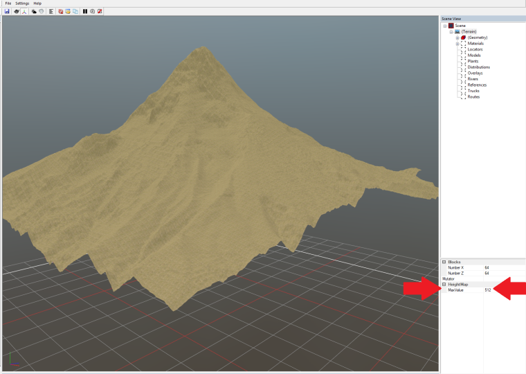
And this is the kicker...the Height Map Max Value. YOU DO NOT NEED TO MESS WITH THE BRIGHTNESS OR CONTRAST OF THE HEIGHT MAP IMAGE TO ACHIEVE MORE REALISTIC HEIGHT DIFFERENTIALS! You can. But it's not the best way to do it IMO. If you want a more realistic height differential scenario(greater elevation, and greater changes in elevation) just use SpintiresMod with the editor. When you do you will have the option of changing the Height Map Max Value. The reason your imported height map looks so blah...is because the Height Map Max Value is in the editor is WAY TOO LOW by default! It's 64m by default. Meaning the difference in height between the lowest point on the map and the heighest point on the map can only be 64m. Weak sauce! I can jump that high(not really...but you get my point). Anyway, using STM you can set the Height Map Max Value in incremental values ranging from 64m(default) all the way up to 4096m. And the results you'll see from doing so can be spectacular. You will probably get some "stepping" in the elevation changes(you'll see what I mean by that). But these can easily be fixed using the geometry height tool/brush in flatten mode. The Height Map Max Values for maps made using STM are stored in an XML file named _mod in the map's prebuild folder. You can change the value there and save it, or from within the editor.
_mod.xml example:
<?xml version="1.0" encoding="UTF-8"?>
<TerrainMod>
    <MaxHeight>512</MaxHeight>
</TerrainMod>
From within the editor:
And that's the basic gist of it. Pretty simple and easy stuff really. I'll add more tips and tricks if/when I find them.